Visualizzazione post con etichetta land annexation. Mostra tutti i post
Visualizzazione post con etichetta land annexation. Mostra tutti i post
martedì 30 ottobre 2007


giovedì 25 ottobre 2007
Map of Apartheid Roads in the West Bank
Apartheid Masked as Peace, Posted in October 24th, 2007
for map:

The law as roadkill on Highway 443
Akiva Eldar, Haaretz, 27.09.07. There is no order that can give legal validity to discrimination among travels according to nationality. In reply to a question from Haaretz, the IDF Spokesman has confirmed that "in light of the many security risks and threats to traffic on Highway 443 in recent years, it was decided in the Israel Defense Forces Central Command to close several approach roads that connect directly from the village expanse to the highway." At the same time, the spokesman stresses that "no order has been issued that prohibits travel on the highway," and in any case, "there is no prohibition on the part of the IDF regarding Palestinian traffic on the segment of the highway located in the territories of the Judea and Samaria [West Bank] area." Nevertheless, in the same statement in which it is claimed that "there is no prohibition regarding Palestinian traffic on the Palestinian segment of the road," it is also stated that because of the security risks, some of the approach roads that link the villages to the highway are closed "permanently."
According to the statement, some of the other roads are open and "are closed in accordance with the assessment of the security situation." Attorney Limor Yehuda of the Association for Civil Rights in Israel (ACRI), who is preparing a petition to the High Court of Justice on the matter, sees the situation differently. According to her, most of the roads are usually closed, and from time to time special permission to use the road is given to a limited number of cars. Some of the approach roads have been blocked with boulders, others with concrete barriers, and there are those that have been closed with iron gates. A Palestinian driver who is caught on the road can expect a lengthy delay, a warning and a scare, and sometimes even the confiscation of the keys to the vehicle and also harsher sanctions. Last May ACRI applied to the GOC Central Command, Yair Naveh, on behalf of the heads of the village councils of Beit Sira, Beit Likiyeh, Hirbet al-Masbah, Beit 'Ur al Tahta, Beit 'Ur al Fuqa and Tsaffeh. Yehuda noted that Highway 443 is the main approach road that links the 25,000 inhabitants of the six villages to the main city in the area, Ramallah, and serves as a link among these villages. Trips in the area have become prolonged, dangerous and costly. Instead of a trip of a quarter of an hour in comfortable conditions on Highway 443 from the village of Beit Sira to Betunya and from there to Ramallah, the inhabitants have to wind their way along dirt roads that become impassable on winter days. The cost of the trip has more than doubled and many of the inhabitants of the villages are unable to bear the costs.
This is not a matter of preventing Palestinians from entering territories on the Israeli side of the Green Line (the pre-Six Day War border), but rather of a road that is located entirely in the area of the West Bank. At the two entrances to the territory of the state of Israel there are roadblocks that are permanently manned by soldiers (the Maccabim roadblock and the Atarot Junction roadblock). When lands of the six villages were confiscated in the 1980s and the 1990s, it was explained to the inhabitants that widening the road was essential for the needs of the inhabitants of the entire area. Including their needs, of course. In response to the petition to the High Court of Justice concerning the confiscation of lands for purposes of paving a road in the Ramallah area, the state argued that the planning "took into account the conditions and needs of the area and not only Israel's conditions and needs." Based on that principled commitment, Justice Aharon Barak rejected the petition in September 1983, and issued a ruling in principle that the rules of international public law grant the right to a military government to infringe on property rights if a number of conditions are fulfilled. The first of these conditions: "The step is taken for the benefit of the local population."
According to the statement, some of the other roads are open and "are closed in accordance with the assessment of the security situation." Attorney Limor Yehuda of the Association for Civil Rights in Israel (ACRI), who is preparing a petition to the High Court of Justice on the matter, sees the situation differently. According to her, most of the roads are usually closed, and from time to time special permission to use the road is given to a limited number of cars. Some of the approach roads have been blocked with boulders, others with concrete barriers, and there are those that have been closed with iron gates. A Palestinian driver who is caught on the road can expect a lengthy delay, a warning and a scare, and sometimes even the confiscation of the keys to the vehicle and also harsher sanctions. Last May ACRI applied to the GOC Central Command, Yair Naveh, on behalf of the heads of the village councils of Beit Sira, Beit Likiyeh, Hirbet al-Masbah, Beit 'Ur al Tahta, Beit 'Ur al Fuqa and Tsaffeh. Yehuda noted that Highway 443 is the main approach road that links the 25,000 inhabitants of the six villages to the main city in the area, Ramallah, and serves as a link among these villages. Trips in the area have become prolonged, dangerous and costly. Instead of a trip of a quarter of an hour in comfortable conditions on Highway 443 from the village of Beit Sira to Betunya and from there to Ramallah, the inhabitants have to wind their way along dirt roads that become impassable on winter days. The cost of the trip has more than doubled and many of the inhabitants of the villages are unable to bear the costs.
This is not a matter of preventing Palestinians from entering territories on the Israeli side of the Green Line (the pre-Six Day War border), but rather of a road that is located entirely in the area of the West Bank. At the two entrances to the territory of the state of Israel there are roadblocks that are permanently manned by soldiers (the Maccabim roadblock and the Atarot Junction roadblock). When lands of the six villages were confiscated in the 1980s and the 1990s, it was explained to the inhabitants that widening the road was essential for the needs of the inhabitants of the entire area. Including their needs, of course. In response to the petition to the High Court of Justice concerning the confiscation of lands for purposes of paving a road in the Ramallah area, the state argued that the planning "took into account the conditions and needs of the area and not only Israel's conditions and needs." Based on that principled commitment, Justice Aharon Barak rejected the petition in September 1983, and issued a ruling in principle that the rules of international public law grant the right to a military government to infringe on property rights if a number of conditions are fulfilled. The first of these conditions: "The step is taken for the benefit of the local population."
The road to Apartheid: Palestinian nonviolent protestors block Road 443. ACRI en demande la réouverture au trafic palestinien

Apartheid Masked as Peace, 24.10.07. An anti-apartheid protest today blocked busy Highway 443, one of many highways that run on occupied Palestinian land but are reserved for Israelis only. Israeli Security forces used force to move the demonstrators. Two of the protesters, one Israeli and one American, were arrested and are being held in an Israeli police post. The protesters blocked the highway for over fifteen minutes by organising a mass sit down in the road backed by six protestors chained into a four metre pipe. Rush hour traffic was backed up for miles before the protestors were removed by force. They distributing a message to the drivers on the highway: “We know what it feels like to be blocked. We experience it daily.”
24.10.07, L’ACRI, l’Association pour les Droits Civiques en Israël a présenté une requête devant la Haute Cour de Justice pour demander à l’Etat de rouvrir la route 443 à la circulation des piétons et des véhicules palestiniens. L’accès à la route, qui traverse la Cisjordanie, est actuellement limité seulement aux Israéliens.
ACRI a présenté ce matin une plainte à la Haute Cour de Justice contre le Ministre de la Défense, le commandant des FDI pour la Judée et la Samarie, et le commandant de la Brigade Binyamin, qui demande un libre accès à la route 443 pour les habitants palestiniens. La pétition demande également à la Cour d’ordonner le retrait des obstacles physiques permanents qui ont été placés à la sortie des six villages qui sont situés à proximité de la route.
La pétition a été présentée par l’avocat de l’ACRI, Limor Yehuda, au nom des chefs de six villages et de 18 autres résidents de la région.
La route 443 est la seule grande route dans le sud du district de Ramallah, et la principale artère reliant les villages de la région à Ramallah. La route date du Mandat Britannique, et avant le début du Second Intifada, elle était la principale artère utilisée par les habitants locaux, y compris par les habitants des villages signataires de la pétition.
martedì 23 ottobre 2007
Restriction on movement. Route 443 – West Bank road for Israelis only.

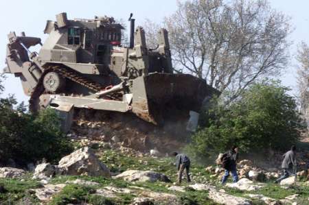
B'Tselem. Route 443, which links Jerusalem and the Tel Aviv area, used to be a major Palestinian traffic artery in the southern Ramallah District and was the main thoroughfare between Ramallah and the Palestinian villages lying southwest of the city. Prior to the second intifada, which broke out in September 2000, Israel widened the road – requisitioning private Palestinian property in the process – into a four-lane highway. Israel contended that the land was taken to meet the needs of the local population and promised that the local villagers would be allowed to use it.
Despite the promise, in 2002, Israel prohibited Palestinians to travel by car or foot on the fourteen kilometers of the roadway that lie in the West Bank . The prohibition also applied in emergency medical cases and to the transport of goods for the surrounding Palestinian villages. Palestinians were left with a one-lane road connecting the villages to the road to Ramallah and for travel between the villages. This alternate road was worn and winding and passed through a tunnel under Route 443. It was much longer than the original road and served all the 35,000 residents of the villages lying on either side of the road.
The prohibition on Palestinian travel on Route 443 was never authorized by military order or by any other legal means. It was effectively implemented by physical obstructions – iron gates, concrete blocks, and/or checkpoints and later by army patrols, which stopped and punished Palestinians caught driving or walking along the road, to make it clear to Palestinians that they were not allowed to use the road. Subsequently, the Israel Police began to enforce the prohibition, and issued tickets, on one pretext or another, to Palestinians using the road. At both ends of the road, where it entered Israeli territory (Maccabim Checkpoint) or Jerusalem 's jurisdictional area (Atarot Checkpoint), Israel set up permanent checkpoints at which the vehicles crossing were checked. This situation continues today.
Map of road 443. Road connecting the villages were blocked by the army.
Full map
Movement along Route 443 is crucial to the villagers. For many of them, this is the main roadway taking them to their farmland and the primary access road to Ramallah. Ramallah is the commercial center on which the villagers rely for their livelihood, for emergency services, social services, hospitals, schools, as well as being the home of relatives and friends. As a result of the prohibition, more than one hundred small shops have closed along the route, among them floor-tile establishments, flower shops, furniture stores, and restaurants.
To “compensate” the villagers for the prohibition on using the road, Israel has built three roads, referred to by the authorities as “fabric of life” roads, to connect the villages with Ramallah. Construction of these roads entailed the taking of additional land from the villages and villagers located on and alongside these roads. The route of the roads is longer than Route 443 and passes through the local villages. In addition, the alternate roads are intended to perpetuate the existing situation, in which Palestinians are prohibited to use the main road, which, as stated, passes across their land, and despite Israel 's promise that these landowners would be allowed to use it.
The prohibition infringes the right of Palestinians to freedom of movement, and, as a result, their ability to exercise other rights, such as the rights to health, work, family and social life, and education. The “fabric of life” roads that Israel built also infringe the property rights of Palestinian villagers in the area.
Israel has the right and even the duty to protect the lives of every person on territory under its effective control, including territory it occupies. Israel also has the right to impose restrictions on movement of Palestinians, but only when needed for security reasons and in accordance with the principle of proportionality. The prohibition on Palestinian use of Route 443 appears to be based on extraneous reasons, the most important being Israel 's desire to annex, de facto, the area along which the road runs. The road is a main thoroughfare between two parts of Israel , Jerusalem and the Tel Aviv area. If Israel were only interested in protecting the lives of Israelis using the road, without annexing the area, it could limit or even prohibit the travel of Israelis on the road, and build other roads and provide other means of transportation to connect Jerusalem and Tel Aviv.
The prohibition on travel also flagrantly breaches international law, which forbids collective punishment. According to Israel , the restrictions on movement are part of its ongoing struggle against security threats, and are intended for deterrence and not as punishment. However, the vast majority of the persons suffering from the prohibition are not personally suspected of posing any threat to Israeli security. The prohibition also constitutes discrimination based on the national origin of the person wanting to use the road. Such discrimination is forbidden under international law.
In July 2007, residents of six of the villages along the route, represented by the Association for Civil Rights in Israel , petitioned the High Court of Justice to remove the obstructions that deny them access to the road, and to open the road to Palestinian travel. In response, the army announced that it would allow eighty vehicles from the petitioners' villages to use the road. They would be allowed to use the road only during the day. Travel at night would be allowed for humanitarian needs, following coordination with the Civil Administration. Palestinian vehicles could enter the road via the checkpoint near Khirbata al-Misbah and continue to the village of al-Jib, where the vehicles would switch to the “fabric of life” roads that link the village with Ramallah. The new arrangement is supposed to begin this month (October) and continue until May 2008, when the army will reconsider its necessity.
This arrangement will provide for only partial movement of villagers living along Route 443 to and from Ramallah. Also, it does not solve the issue of principle, that of the army placing prohibitions and restrictions on Palestinians using the road. With a limited number of Palestinian vehicles allowed to use the road, and with the travel being limited to daylight hours, many Palestinians will continue to be restricted from exercising basic human rights, such as family visits and regular travel to their places of work.
Route 443 is one example of the travel-prohibition regime Israel imposes on Palestinian vehicles on various roads in the West Bank . B'Tselem calls on the Israeli authorities to immediately remove the prohibition on Palestinian travel on Route 443, and to allow residents of the nearby villages open use of the road, day and night. B'Tselem also urges the authorities to remove similar restrictions on other roads in the West Bank, among them Route 557, which runs from the Huwara checkpoint to the villages of Beit Furik and Beit Dajan, and to the Elon Moreh settlement, in Nablus District, and Route 90 (the Jordan Valley road), which is the main north-south artery in the Jordan Valley.
Iscriviti a:
Post (Atom)