Visualizzazione post con etichetta checkpoints. Mostra tutti i post

lunedì 3 dicembre 2007

Separate but Unequal in Palestine: The Road to Apartheid

Mohammed Khatib, Dissident Voice, 2.11.07. When United States Secretary of State Condoleezza Rice visited the Middle East a few weeks ago, people from our small village of Bil’in joined neighboring villages to send her a message. We protested peacefully against a West Bank highway near us that is reserved for Jewish Israeli settlers, and off-limits to Palestinians, though it was built on Palestinian land. Our banner read: “Condi, What would Rosa Parks do?”

We know that Dr. Rice experienced the bitter taste of discrimination growing up in the South during the US civil rights struggle. In Bil’in, we’ve drawn inspiration from the US civil rights movement as we’ve carried out a three year nonviolent resistance campaign against the discriminatory policies of Israel’s military occupation.

We share Dr. Rice’s admiration for the courage of Rosa Parks who was arrested in Alabama, Rice’s home state, for refusing to give her bus seat to a white man. As Palestinians we aren’t even allowed in buses on many roads in our own country, because 200 miles of the best West Bank roads are reserved for Israeli Jewish settlers.1 The color of Palestinian license plates is different from the licenses of Israelis. Palestinian plates are not allowed on most of the highways crisscrossing the West Bank, many of which were built with US government funding. Palestinians have been banned for five years now from Highway 443 where we protested.

According to the United Nations Office for the Coordination of Humanitarian Affairs (OCHA), there are 561 physical obstacles and checkpoints inside the West Bank restricting Palestinian movement within the West Bank,2 in comparison with only eight checkpoints which separate the West Bank from Israel proper. Nearly all the obstacles and checkpoints are located along the West Bank roads reserved for Israelis. This makes getting to the hospital, school and work or visiting relatives painstakingly difficult or impossible for us. This fragmentation of the West Bank has devastated our economy.

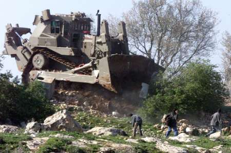
In 2001, Israeli developers began building settlement homes on land seized from Bil’in, calling them a neighborhood of the Modi’in Illit settlement bloc. Four years later, Israel’s segregation wall separated Bil’in from 50% of our agricultural land under the pretext of protecting this new settlement. In response, we held over 200 nonviolent protests together with Israeli and international supporters. Hundreds of us were injured and arrested. After our protests, Israel’s Supreme Court ruled that the wall’s route in Bil’in must be changed to return around half of our seized land. Though we celebrated this success, Israel continues to build on our land that wasn’t returned and plans to annex it as part of the Modi’in Illit settlement bloc.4

Israel has already de facto annexed the 10.2% of the West Bank that lies between the Green Line and the segregation wall, including the major settlement blocs and 80% of Israel’s 450,000 settlers. The segregation wall, settlements and settlement roads carve Palestinian areas into isolated enclaves.

We pray that our children will not spend their lives under Israeli military occupation. We hope that the Annapolis meeting will bring our dreams of freedom closer to fulfillment. But we are concerned that if Israel is allowed to keep most of its settlements and the roads that connect them, then the existing system of “separate but unequal” will be cemented in place in a Palestinian state.

  1. Forbidden roads: The discriminatory West Bank road regime, B’Tselem. #
  2. OCHA Closure Update: October 2007, The UN Office for the Coordination of Humanitarian Affairs. #
  3. West Bank settlements ‘expanding’ BBC, 7 November 2007. #
  4. One Palestinian Village Struggles Against Israel’s Ever-Expanding “Settlements”, Alternet, 26 September 2007. #
Mohammed Khatib is a leading member of Bilin's Popular Committee Against the Wall and the secretary of its village council. Read other articles by Mohammed, or visit Mohammed's website.

martedì 11 settembre 2007

Checkpoints: What's the Point?


Eileen Hanson, Christian Peacemaker Teams, 11/09/07. After waving a pick-up truck along, one soldier pointed the laser guide of his automatic weapon at the abdomen of the young boy riding in the back of the truck. The boy said something, and then the laser point moved, appearing next on the child's face. It was then I thought I could see the point, tragic and awful as it is. It isn't about finding weapons or stolen cars. It's not about finding the bad guy. It's a display of power. Checkpoints are a way of reminding everyone, even the kids, who's in charge. If that's the point, then these flying checkpoints certainly do that.

The last two Friday nights, the Israeli army set up a 'flying' (temporary, mobile) checkpoint just outside Tuwani. Checkpoints on the highway beside Tuwani are a regular occurrence. One jeep, four soldiers and a string of spikes across the road constitute a checkpoint. Each time the soldiers show up, we go down to the road to monitor what is happening. We document the checkpoint, as well as any searches that take place and are present to respond in case of abuses.

Typically these temporary checkpoints last a few hours. Soldiers stop cars, check ID's and search a few trunks. Much of the traffic in the area is actually foot traffic, people walking from villages around Tuwani to and from the nearby city of Yatta. Men, women and children, including infants in their mothers' arms, are checked. Aside from settler traffic on the highway, which does not have to stop, soldiers mostly see a lot of tractors and sheep trailers. I wondered this Friday if they were going to search the sheep!

After seeing this countless times and failing to see the point, last night I asked one young soldier on duty what they were doing. He said they were "looking for stolen cars or weapons." Still curious I followed up, "Do you find a lot of weapons this way?" "No. The people with the weapons see the checkpoint and make a U-turn. There's nothing we can do." Since I felt he understood me, and also because I was tired of standing around on a cold windy night, I pressed a bit and said, "So that makes this kind of pointless, huh?" Now were both smiling, and he said, "Yes. If it were up to me, I'd be home in bed."

They can't possibly find anything using this method. Not that I'm convinced there's anything to find. The soldiers and jeeps are visible from a half mile away. Anyone who might be trying to move contraband could simply wait until the soldiers leave. Everyone knows this, including the soldiers.

But there must be some point to it. Otherwise why are these soldiers ordered time and time again to set up these checkpoints?

On Saturday, soldiers again set up a flying checkpoint just outside Tuwani. This group of soldiers seemed particularly dangerous. They were wrestling with one another and pointing the laser guides of their automatic weapons at objects in the darkness. They were rude and rowdy, particularly as the evening wore on. When they turned up the American rock and roll music, I wondered if this is what the US occupation in Iraq looks like.

After waving a pick-up truck along, one soldier pointed the laser guide of his automatic weapon at the abdomen of the young boy riding in the back of the truck. The boy said something, and then the laser point moved, appearing next on the child's face.

It was then I thought I could see the point, tragic and awful as it is. It isn't about finding weapons or stolen cars. It's not about finding the bad guy. It's a display of power. Checkpoints are a way of reminding everyone, even the kids, who's in charge. If that's the point, then these flying checkpoints certainly do that.


Christian Peacemaker Teams is an ecumenical initiative to support violence reduction efforts around the world. To learn more about CPT's peacemaking work, visit our website www.cpt.org Photos of our projects are at www.cpt.org/gallery A map of the center of Hebron is at http://www.reliefweb.int/rw/fullMaps_Sa.nsf/0/5618737E38C0B3DE8525708C004BA584/$File/ocha_OTS_hebron_oPt010805.pdf?OpenElement The same map is the last page of this report on closures in Hebron: www.humanitarianinfo.org/opt/docs/UN/OCHA/ochaHU0705_En.pdf