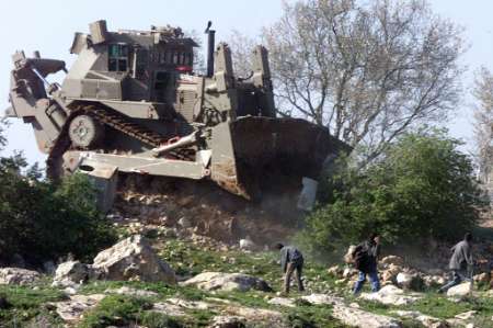
QALQILYA, 26 July 2007 (IRIN) - Three years ago, in July 2004, the International Court of Justice (ICJ) in the Hague issued an advisory opinion, which, by a vote of 14 to one, declared the barrier illegal, and expressed particular concern that parts of it were being built within the occupied Palestinian territory.
In the Qalqilya district of the northern West Bank, many Palestinians were separated from their agricultural land and livelihood, because the barrier did not always follow the internationally recognised ‘green line’ between Israel and the Palestinian area.
Others found themselves divided from the rest of the West Bank. Overall, about 15 villages remain in the ‘seam zone’ between the serpentine path of the barrier and the border. According to the UN Office for the Coordination of Humanitarian Affairs (OCHA), 50,000 Palestinians will be located in that zone when the barrier is complete.
The ICJ observed that these pockets were created for the benefit of Israeli settlements, which it declared were also illegal under international humanitarian law.
Visualizzazione post con etichetta The Wall width. Mostra tutti i post
Visualizzazione post con etichetta The Wall width. Mostra tutti i post
venerdì 27 luglio 2007


mercoledì 18 luglio 2007
Width Matters Displacement and Israel's Wall
Susan Miller. Counterpunch. 17/07/07. The term, "The Wall" , is dismissed by Israel as a misrepresentation of the controversial structure it is building. Supporters of Israel claim that only a small percent of the structure consists of a 25 feet [7.62 m] high concrete wall. The structure is more accurately understood by its width, not its height. Winding its way down from the northern most point of the West Bank it leaves in its wake a 65 [60 m] to 87 yard [79 m] wide swath of bulldozed land on which trenches, barbed wire, footprint tracer paths, a two-lane patrol road and watch towers have been placed. From edge to edge, the structure exceeds the width of six lane segments of Interstate 95 or half the length of a football field. Cities, towns and villages are already separated by 250 running miles [402 km] of by-pass roads built on Palestinian land and designated for Israeli use only. In conjunction with hundreds of checkpoints and road barriers, Palestinians are constantly bumping up against the physical manifestations of Israeli settlement that deny them freedom of movement and the ability to live normal lives.
Width matters. Semantic disputes concerning the Israeli Palestinian conflict have existed for years. Arguments continue over Jimmy Carter's use of the word "apartheid" to describe the system under which Palestinians live in Israeli administered areas. These areas are called "Judea-Samaria" and considered "disputed" land by the Israeli camp while others refer to them as the "West Bank" and "occupied". Finally the term, "The Wall" , is dismissed by Israel as a misrepresentation of the controversial structure it is building. Supporters of Israel claim that only a small percent of the structure consists of a 25 feet [7.62 m] high concrete wall. The remainder is considered a simple wire "fence" that can not be equated with a wall. In reality, neither of these descriptors conveys the structure's essential nature.
Width matters. Semantic disputes concerning the Israeli Palestinian conflict have existed for years. Arguments continue over Jimmy Carter's use of the word "apartheid" to describe the system under which Palestinians live in Israeli administered areas. These areas are called "Judea-Samaria" and considered "disputed" land by the Israeli camp while others refer to them as the "West Bank" and "occupied". Finally the term, "The Wall" , is dismissed by Israel as a misrepresentation of the controversial structure it is building. Supporters of Israel claim that only a small percent of the structure consists of a 25 feet [7.62 m] high concrete wall. The remainder is considered a simple wire "fence" that can not be equated with a wall. In reality, neither of these descriptors conveys the structure's essential nature.
The structure is more accurately understood by its width, not its height. Winding its way down from the northern most point of the West Bank it leaves in its wake a 65 [60 m] to 87 yard [79 m] wide swath of bulldozed land on which trenches, barbed wire, footprint tracer paths, a two-lane patrol road and watch towers have been placed. From edge to edge, the structure exceeds the width of six lane segments of Interstate 95 or half the length of a football field.
When one considers the expansive reach of the structure and that eighty percent of it has been built on Palestinian land, the enormity of its impact on Palestinian society is understood. Local and international NGO's concur that the completed sections of the planned 416 mile long structure have incurred property damage numbering in the tens of thousands of agricultural and grazing acres destroyed, olive and fruit trees uprooted, homes, commercial buildings, greenhouses, infrastructure and water wells demolished.
These figures do not take into account the social deprivations caused by the bisecting of villages in the structure's path. Thousands of Palestinians have been dislocated or separated from families, employment, medical services, schools, farms and water sources. Cities, towns and villages are already separated by 250 running miles [402 km] of by-pass roads built on Palestinian land and designated for Israeli use only. In conjunction with hundreds of checkpoints and road barriers, Palestinians are constantly bumping up against the physical manifestations of Israeli settlement that deny them freedom of movement and the ability to live normal lives.
The terms "Wall" and "Fence" mistakenly evoke an image of the vertical displacement of mere air. These terms fail to convey the permanent displacement at ground level of enormous expanses of land, property and people. Understanding width matters. It imparts a realistic understanding of the structure's impact on Palestinian society and its long term effects on the possibility of an independent state. It affirms long standing Palestinian grievances which are commonly denied. It illuminates Israel's extensive violations of international laws designed to protect occupied peoples. It widens the public's perspective on Palestinian/Israeli issues and the understanding that for peace to succeed justice matters.
Susan Miller is an American and Israeli citizen who lived in Jerusalem from 1969-1980. She is active in organizations working for peace in the Middle East. She currently resides in Philadelphia, Pennsylvania.
http://www.counterpunch.org/miller07172007.html
http://www.counterpunch.org/miller07172007.html
Iscriviti a:
Post (Atom)